Bengaluru · Step 2 of school-first: the commute
What a school morning looks like from the school bus.
This is a directional model, not a forecast: a simulation of one weekday morning on Bengaluru’s main roads, with every school bus, parent car, two-wheeler and commuter. Real mornings are usually worse, so treat its times as a floor.
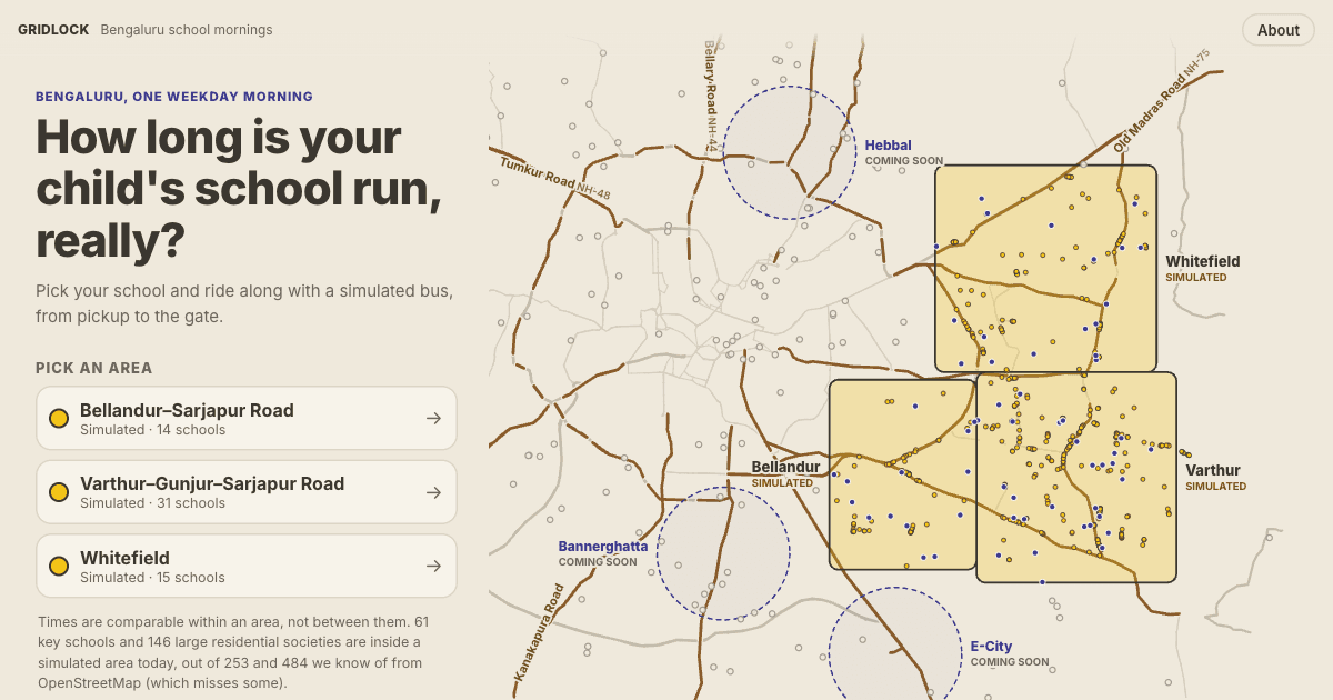
Pick a school, pick where you live, and ride along with one illustrative child from pickup to the gate. It covers Varthur–Gunjur–Sarjapur Road, Whitefield and Bellandur–Sarjapur Road today.
Downloads about 1–2 MB per area. Works best on a recent phone or laptop browser (Safari 16.4+).
What it shows
- How early school-bus pickups start, and how the morning peak builds road by road.
- Which main roads school buses share with office traffic, and where they queue.
- One illustrative child’s door-to-gate trip, with time stuck in jams and the walk to the stop.
- The spread within an area: a typical trip next to the longest ones.
What it does not show
- Any school’s real timetable. Bell times, bus numbers and enrolment are assumed for every school, not taken from the schools.
- Side streets, rain, breakdowns, parking at the gate, or the afternoon run.
- A prediction of your own trip. Ask the school for its route and time the drive yourself.
- A ranking of schools or areas. Nothing here says one school or area is better than another.
Coverage
Simulated areas
Times are for the simulated baseline morning, across three runs of the model. The longest trips figure is the 95th percentile: 1 in 20 children on a school bus takes at least that long, door to gate. The typical trip is the median. Compare within an area, not between areas: each is tuned separately, and Bellandur runs with less traffic in the model than the other two.
| Area | Schools simulated | Typical trip | Longest trips (95th pct.) |
|---|---|---|---|
| Varthur–Gunjur–Sarjapur RoadVarthur, Gunjur, Balagere and Sarjapur Road down to Dommasandra | 31 | 32 min – 34 min | 1h 07m – 1h 08m |
| WhitefieldWhitefield, ITPL, EPIP Zone, Hoodi, Kadugodi and Brookefield | 15 | 31 min – 35 min | 1h 08m – 1h 09m |
| Bellandur–Sarjapur RoadBellandur, Agara, Iblur, Kaikondrahalli and Sarjapur Road towards Carmelaram | 14 | 28 min – 30 min | 1h 17m – 1h 24m |
Coming later: Hebbal–Manyata–Thanisandra, Bannerghatta Road, Electronic City. North Bengaluru schools such as Stonehill, Canadian International, Mallya Aditi and Vidyashilp are not covered yet. Model v0.3.0, data generated 23 September 2026.
School first, then commute
How to use it in your decision
1. Shortlist schools
By curriculum, grade seats and fit. Use the School DB.
2. See the areas around them
The map shows communities near each school, with rough distance rings.
3. Watch a morning
In a simulated area, see which roads the buses share and how early pickups start.
4. Check the real route
Ask the school for its bus route and pickup time from your society, and drive it on a school-day morning.
From the School DB
School DB schools inside a simulated area
These links open the simulator on the school’s area. What you see there is the model’s assumed timetable, not the school’s own, and says nothing about the school itself.
- Neev AcademyBellandur–Sarjapur Road · open the model
- Delhi Public School Bangalore EastVarthur–Gunjur–Sarjapur Road · open the model
- Greenwood High International SchoolVarthur–Gunjur–Sarjapur Road · open the model
- Inventure AcademyVarthur–Gunjur–Sarjapur Road · open the model
- Oakridge International School, BengaluruVarthur–Gunjur–Sarjapur Road · open the model
- The International School BangaloreVarthur–Gunjur–Sarjapur Road · open the model
- Ekya School, ITPLWhitefield · open the model
Questions
Are these real school bus times?
No. It is a computer simulation of one weekday morning on the main roads, built from OpenStreetMap roads and school locations. Bell times, bus numbers and enrolment are assumed for every school, not taken from the schools. Use it to see how a morning builds up, not to predict your own trip.
Why might real mornings be worse than the simulation?
Only main roads are simulated, with no rain, no breakdowns, no parking at school gates and no side-street shortcuts. Parents report school runs of well over an hour on some of these roads, so treat the simulated times as the good case.
Can I compare the areas with each other?
Not reliably. Each area is tuned separately, and Bellandur runs with less traffic in the model than Varthur and Whitefield, so a difference between areas may come from the model rather than the roads.
How should I use it when choosing a school and a home?
Shortlist schools first, then use the simulator to see which roads the school buses share and how early pickups start. Then do the real check: ask each school for its bus route and pickup time from your society, and time the drive yourself on a school-day morning.
Data and licences
- Roads, school locations and place names come from © OpenStreetMap contributors. The simulation’s data files are derived from OpenStreetMap and available under the Open Database License 1.0. Simulated with Eclipse SUMO.
- School, society and place names belong to their owners and appear only to identify locations. No affiliation, sponsorship or endorsement is implied, and nothing here is official.
- The simulator sets no cookies and never sends where you live. See the privacy page.